There are 18 management compartments and 44 subcompartments, retained from the original management plan produced in 2000.
These are areas containing one habitat type (or a small number of habitats), or are areas visually defined by surrounding boundaries and features, therefore forming a convenient basis for dividing the plan into manageably-sized sections.
Some of the defining boundaries were old airbase features (e.g. roads, runways, taxiways, dispersal areas) which are now much less prominent or even invisible on the ground.
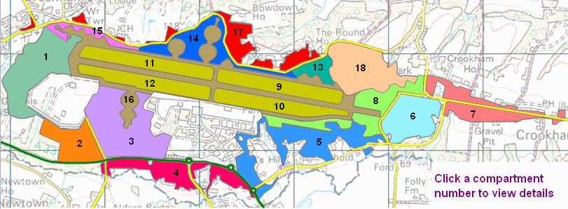
Compartment 1: Sandleford Heath (1C) & adjacent areas
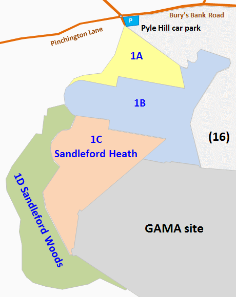
The western end of the common. It contains a mix of mature heath and woodland habitats, with some heavily disturbed areas.
The four subcompartments have a total area of 34.2 ha. 1A is immediately south of the Pyle Hill car park and entrance onto the common. 1B includes the far western end of the former runway. 1C is an area of heathland known as Sandleford Heath, and 1D is Sandleford Woods.
The majority of subcompartments 1A, 1C and 1D lie outside the former airbase. The whole compartment is within the stock fence and therefore available for grazing.
Compartment 2: Brackenhurst Heath (2A) & Peckmoor Copse (2B)
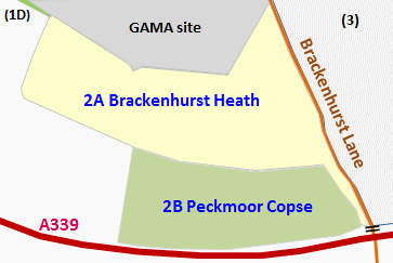
An area of the common between the cruise missile bunker area (GAMA site, not part of the common) to the north, the A339 Basingstoke road to the south and Brackenhurst Lane to the east. Land to the west is not part of the common, except for a narrow strip adjacent to the southwest corner of the GAMA site, which connects with Compartment 1. Compartment 3 lies to the east, beyond Brackenhurst Lane.
There are two distinct subcompartments with a total area of 17.9 ha, the first known locally as Brackenhurst Heath, and the second as Peckmoor Copse. Brackenhurst Heath was the site of one of the peace camps, and some artwork and earthworks are still visible. Peckmoor Copse is a fragment of a larger wood that was once managed for oak and hazel coppice. The whole compartment is available for grazing.
Compartment 3: Aldernbridge Gully (3A), Ballshill & Handpost Gullies (3B) & surrounding areas
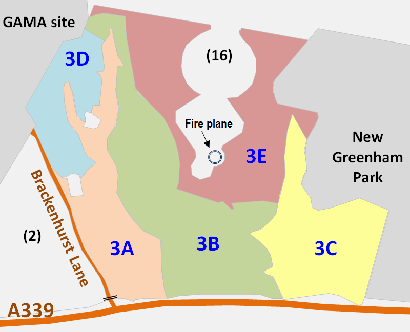
This is the area between Brackenhurst Lane and the GAMA site to the west, and New Greenham Park to the East. The compartment borders the A339 to the south, and its northern boundary is the old southern taxiway. However it excludes the gravel area (part of Compartment 16) that marks the site of an old aircraft turning pan and the area around the fire plane. This is a relatively large compartment totalling 40.78 hectares split into 5 subcompartments. 3A is Aldernbridge Gully, 3B is Aldernbridge (or Ballshill) Heath and 3C includes Handpost Gully, Ballshill Gully and Peaked Hill.
The compartment is a microcosm of the whole site with areas of wet woodland, ponds, bare gravel, scrub, wood pasture, secondary woodland, dry heath and acid grassland. The whole area (with the exception of some exclosures set up for botanical monitoring in the valley bottoms) is available for grazing.
Compartment 4: Clarke's Gully (4A), Bishops Green Heath (4B), etc.
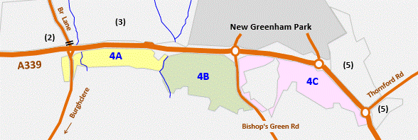
Compartment 4 lies south of the A339 Newbury-Basingstoke Road, stretching in a linear form from west to east and divided into 3 subcompartments. The habitats are made up of wooded wet gullies, lowland heathland and semi-natural woodland with a small amount of pine plantation. There are access tracks to a string of properties, and the compartment is dissected again by Bishops Green Road. Compartments 4A (Clarke's Gully) and 4B (Bishops Green Heath) are SSSI. The area is not stock fenced and not grazed.
Compartment 5: Martindale (5A), Heads Hill and Goldfinch Bottom (5C), Brushwood Gully (5D), etc.
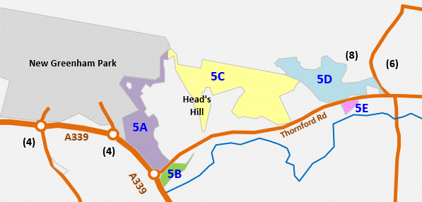
Compartment 5 is the southeastern area of the common, comprising land south and east of New Greenham Park, extending eastwards as far as Old Thornford Road and including two areas on the south side of Thornford Road. The five subcompartments are separated and partly defined by roads, properties and areas which are not part of the common.
Of the five, only subcompartments 5C and 5D are easily accessible from the main common (the narrow connection in the north of 5A is overgrown and necessitates climbing at least one fence). All of 5C except the southern part of Heads Hill, and all of 5D are within the stock fence and accessible for grazing.
Compartment 6: Crookham Common (east & south of Old Thornford Road)
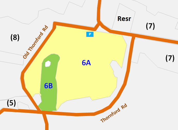
The southeastern end of the old airfield, its perimeter delimited by the surrounding roads. A reasonably sized compartment of 22.5 ha, it is criss-crossed by a number of informal paths and tracks. The compartment as a whole lies on the edge of the plateau as it starts to shelve away to the south.
The larger subcompartment (6A) is typified by large areas of secondary, mainly birch woodland and scrub interspersed with areas of remnant and restored heathland. This surrounds subcompartment 6B, Thornford Gully, an alder gully with birch and oak woodland. The surrounding roads to some extent separate this compartment from the main area of the commons, therefore it is not within the stock fence and not grazed. Heather here is is faring far better than on the main common.
Compartment 7: Easternmost parts of Crookham Common
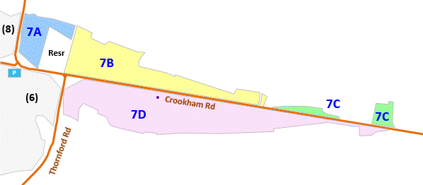
Compartment 7 is 23.7 ha at the extreme eastern end of the common, astride Crookham Common Road which separates subcompartments 7A, 7B and 7C on the north side from 7D on the south.
There are access tracks to a number of properties, and connections with four public rights of way. A well established path traverses the subcompartments on the north side of the road, travelling west-east from Crookham Hill Road to the caravan park entrance, then south of the caravan park almost as far as the Travellers Friend.
The compartment is not part of the stock-fenced and grazed area of the main common, being separated from it by Crookham Hill Road, Old Thornford Road and compartment 6.
The southern edge of subcompartment 7D enjoys some extensive views over the Enborne valley towards the Downs.
Compartment 8: Far eastern end of the main common
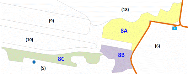
Compartment 8 lies at the eastern end of the old runway, adjoining Old Thornford Road. It comprises 3 subcompartments with a total area of 25.4 ha. There is a broad mixture of habitats - neutral and acid grassland, lowland heath, scrub, secondary woodland and areas of bare gravel. The whole compartment is available for grazing. Subcompartment 8A contains a former POL (petroleum, oil, & lubricants) station, one of the common's more prominent military relics.
Compartments 9, 10, 11 & 12: The central "lozenges"
Compartments 9 to 12 are four parcels (commonly called the "lozenges") occupying a large proportion of the open central plateau. Bordered by the regular layout of the former runway and taxiways, they are all roughly rectangular and are similarly sized at about 20 ha in area. All four are very rich in flora, containing national and Berkshire rarities. They are accessible to grazing livestock.
These four Compartments are arranged as follows:
Compartment 9: The northeastern one of the four
Compartment 10: The southeastern lozenge, 20.6 ha in area.
Compartment 11: The northwestern lozenge.
Compartment 12: The southwestern of the four central lozenges, 19.6 ha in area.
Compartment 13: South of the eastern cattle grid
Compartment 13 covers a 7 ha area immediately south of Bury's Bank Road, west of Crookham Pools (re-landscaped area Compartment 18) and north of the former runway and taxiways. It is not divided into subcompartments. The compartment contains planted woodlands and species rich grassland, and is accessible to grazing livestock.
Compartment 14: Main car park, control tower and adjacent area
Compartment 14 is the central one of three occupying the long east-west strip between the former northern taxiway and Bury's Bank Road. The road defines the northern boundary, while the southern boundary follows old airbase features, with several large incursions of compartment 16 (former runways, taxiways and hardstanding). There is no division into subcompartments, but the compartment comprises two very distinct zones:
A central area encompassing...
- the main visitor car park and surrounding grassland
- the control tower and its surrounding compound, which are owned by Greenham Parish Council.
- the Rangers' workshop (Estovers, formerly airbase building number 616) and service yard, an adjacent stock handling pen and a small area of heathland.
- Another warehouse-style former airbase building (number 150).
This central area is not common land, is fenced off from the main common, and therefore not grazed. This offers some variation from the habitats of the main common.
The remainder of compartment 14, extending both east and west of the central utilty area, is grassland within the grazed part of the main common.
Compartment 15: Northwestern areas of Greenham Common
Compartment 15 runs along the northwestern edge of the common, adjacant to Bury's Bank Road, and covers an area of 7.6 ha. It is not divided into subcompartments. The compartment contains a mix of grassland with fragments of remnant heath, pioneer communities on bare gravel substrate and scrub and mature trees. The area is adjacent to the Pyle Hill car park so is very well used by the public.
Compartment 16: Former runway, taxiways and dispersal areas
Compartment 16 is the areas formerly occupied by the runway, taxiways, dispersal areas and ancillary buildings. It is 77.5 hectares in area, with no division into subcompartments. It, and the four intervening "lozenges" (compartments 9 to 12) together occupy the majority of the generally flat and level central plateau of the common.
Following the acquisition of the common by WBC, civil engineers Raymond Brown removed the majority of the concrete and tarmac, leaving the underlying gravels exposed and completely bare of vegetation. The only major area left untouched was the central cross of the runway and taxiways, which remains as a reminder of the cold war history. Between 1995 and 1999 the operation processed 1.3 million tonnes of material, the crushed concrete being used in the construction of the Newbury bypass. The excavations lowered the ground level of the former runway, relative to the surrounding land, by up to a metre. Some areas were infilled and re-modelled to create slopes, banks and mounds for habitat variety.
Compartment 17: Eight areas north of Bury's Bank Road

Compartment 17 comprises eight subcompartments, all on the north side of Bury's Bank Road, and separated by a number of properties. Subcompartments 17B, C (part) and D are accessible to grazing livestock, which is able to cross the road on the section between the two cattle grids. 17B includes the car parking area for BBOWT's adjacent Bowdown Woods nature reserve.
Compartment 18: Crookham Pools
This 31 ha area once contained buildings and concrete pans of the former airbase which were removed in 2000 to 2001, along with around 1 million tonnes of gravel. The area was re-landscaped to create a variety of landforms including permanent and seasonal pools, and a couple of steep sided, south-facing slopes. Livestock graze throughout the compartment. There is no division into subcompartments.


