A Higher Level Stewardship Agreement with Natural England was signed in September 2008, to run for 10 years until 2018.
Environmental Stewardship is an agri-environment scheme that provides funding to farmers and other land managers in England to deliver effective environmental management on their land.
Higher Level Stewardship (HLS) is in the top tier of options available under this scheme and aims to deliver significant environmental benefits in high priority situations and areas. It involves complex environmental management. There is a wide range of management options available and these are designed to support key features of the different areas of the English countryside. More detail can found on Natural England'sHigher Level Stewardship web page.
The targeted funding and advice available via HLS helps to maintain and enhance the nature conservation value and (implicitly) the biodiversity of the common.
Those areas of the common covered by the SSSI notification are currently (2013) in the scheme. These parts were previously under a Countryside Stewardship Agreement (a forerunner of Environmental Stewardship).
It is hoped to bring additional areas of the common into the agreement during the term of this management plan, to increase the overall benefit to the habitats and the wildlife. Indeed the remainder of compartment 6 has now (2013) been included following completion of heathland restoration work by BBOWT as part of the 'Heathland and beyond' project under the West Berkshire Living Landscape Project.
A structured survey of all environmental features on the land, known as a Farm Environment Plan (FEP) a is a pre-requisite for HLS funding. An FEP has been produced for the whole common, in order that the HLS coverage can be extended.
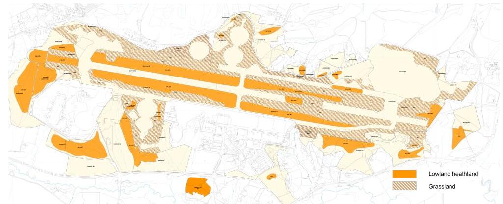
The habitat types covered by the HLS agreement are lowland heathland and species-rich, semi-natural grassland. The map below (Natural England 2008) shows the areas covered by the agreement, as it applies to each habitat type. The agreement also provides funding related to the maintenance of the herd of Exmoor ponies on the common. For more detail, including specific management prescriptions and indicators of success, please see appendices HK6 to HR2.

HLS areas by subcompartment
| Compartment | Subcompartment | ha | Locale | HK6 (MG) | HK7 (RG) | HO1 (MH) | HO2 (RH) | HR2 (NB) |
|---|---|---|---|---|---|---|---|---|
| 01 | 01A | 4.1 | Near Pyle Hill gate | HO1 | ||||
| 01B | 10.7 | End of runway | HK6 | HK7 | HO1 | HO2 | ||
| 01C | 9.6 | Sandleford Heath | HO1 | |||||
| 01D | 9.8 | Sandleford Woods | ||||||
| 02 | 02A | 11.1 | Brackenhurst Heath | HO1 | ||||
| 02B | 6.8 | Peckmoor Copse | ||||||
| 03 | 03A | 7.6 | Aldernbridge Gully | |||||
| 03B | 11.9 | Aldernbridge/Ballshill Heath | HK6 | HO1 | ||||
| 03C | 7.3 | Ballshill Gully, Handpost Gully & Peaked Hill | ||||||
| 03D | 3.8 | Adjacent to east side of GAMA site | ||||||
| 03E | 10.2 | NW of fire plane area | HK6 | HO1 | ||||
| 04 | 04A | 4.6 | Clarke's Gully | |||||
| 04B | 9.2 | Bishops Green Heath | HO1 | |||||
| 04C | 7.2 | East of Bishops Green Road | ||||||
| 05 | 05A | 8.4 | Martindale | HO1 | ||||
| 05B | 1.4 | South of Thornford Road near A339 junction | ||||||
| 05C | 9.6 | Heads Hill & Goldfinch Bottom | HO2 | |||||
| 05D | 8.7 | Brushwood Gully | HO2 | |||||
| 05E | 0.4 | South of Thornford Road | ||||||
| 06 | 06A | 18.6 | Crookham Common east of Old Thornford Road | HO1 | HO2 | |||
| 06B | 3.9 | Thornford Gully | ||||||
| 07 | 07A | 2.4 | North of Crookham Road (w) | |||||
| 07B | 7.4 | North of Crookham Road (e of 7A) | ||||||
| 07C | 1.3 | North of Crookham Road (e of 7B) | ||||||
| 07D | 12.6 | South of Crookham Road | ||||||
| 08 | 08A | 12.0 | HO1 | |||||
| 08B | 4.9 | HK6 | HO1 | |||||
| 08C | 8.5 | HK6 | ||||||
| 09 | 09 | 19.4 | Northeast "lozenge" of former runway/taxiway area | HK6 | HO1 | HR2 | ||
| 10 | 10 | 19.4 | Southeast "lozenge" of former runway/taxiway area | HK6 | HO1 | HR2 | ||
| 11 | 11 | 20.6 | Northwest "lozenge" of former runway/taxiway area | HK6 | HO1 | HR2 | ||
| 12 | 12 | 19.6 | Southwest "lozenge" of former runway/taxiway area | HK6 | HO1 | HR2 | ||
| 13 | 13 | 7.0 | Area to the south of the estern cattle grid on BBR | HK6 | HO1 | |||
| 14 | 14 | 19.5 | Main car park, control tower and adjacent area | HK6 | HO1 | |||
| 15 | 15 | 7.6 | Northwestern areas of Greenham Common | HK6 | ||||
| 16 | 16 | 77.5 | Former runways and subsidiary areas | HK7 | HO2 | |||
| 17 | 17A | 1.0 | Pigeons Farm Road | |||||
| 17B | 9.7 | Approach to Bowdown Woods | HO1 | |||||
| 17C | 1.7 | HK6 | ||||||
| 17D | 5.1 | HK6 | ||||||
| 17E | 0.7 | |||||||
| 17F | 0.3 | Entrance to Pigeons Farm track | ||||||
| 17G | 1.1 | East of Crookham Golf Club | ||||||
| 17H | 0.1 | |||||||
| 18 | 18 | 31.0 | Crookham Pools or relandscaped area | HK7 |
